
Fresno Block Source Records
Different records answer different questions about Fresno neighbors. The parcel map shows the land immediately around an address. FBCAD supplies an appraisal account and mailing relationship. The County Clerk supplies recorded instruments when an ownership trail matters. Community sources can identify an association, but they do not create a public household list. The table keeps those limits visible before a search expands beyond the target parcel.
| Source | What It Shows About a Block | Access |
|---|---|---|
| Fort Bend interactive GIS | Parcel boundaries, subdivisions, CADs, MUDs, thoroughfares, floodplain, and mobility context | Public map browse and parcel-click workflow |
| FBCAD property search | Owner name, mailing address, situs address, legal description, taxing units, and identifiers for an account | Public search; not title certification |
| County Clerk Official Public Records | Deeds, plats, liens, easements, and recorded party history tied to an owner or legal description | Public index; images are unofficial and copies may be purchased |
| Fort Bend Voter Registration Inquiry | Individual civic-registration verification using documented name, birth-date, or VUID methods | Public individual lookup subject to Texas privacy rules |
| Texas HOA management certificates | Association name, county, city, ZIP, type, and certificate link | Public association lookup, not a member roster |
An appraisal owner may have a different mailing address from the situs address. A person listed in a recorded deed may have transferred the parcel later. Treat every entry as a dated record fact, then confirm it with the appropriate custodian before relying on it.
Map a Fresno Block
The documented Fort Bend method is map browse and parcel click, not a verified radius or buffer tool. Begin with one full street address in the GIS viewer. Then work only through parcels that share a boundary with the target, rather than treating all nearby map pins as a block. This keeps the work tied to land records and avoids turning a map view into a claim about who lives nearby.
- Search the exact address with the GIS magnifying glass and identify the target parcel.
- Click each touching parcel and record its parcel ID, legal-description context, situs address, subdivision or section, and taxing-unit codes.
- Use the FBCAD identifiers to open the corresponding appraisal accounts, keeping owner mailing and situs fields separate.
- Search the County Clerk's grantor, grantee, date-filed, or document-type fields only when a recorded ownership or plat question is relevant.
The flow is address to target parcel, touching parcels, FBCAD accounts, then recorded deeds or plats when needed. For a complete named-street chain rather than a single block, use the Fresno street directory, which focuses on the street-by-street record path.
Note: A touching parcel is a land-record relationship, not evidence that the current owner is a neighbor or present occupant.
Fresno Parcel Field Check
Fresno parcel work has a useful four-part check. FBCAD may show a situs address, an owner mailing address, a legal description, and identifiers such as Quick Ref ID or Geographic ID. USPS normalizes a delivery address. A recorded deed adds the grantor, grantee, recording date, instrument number, and legal description. Those fields may point in the same direction, but they serve different purposes.
- Situs address
- The physical property location carried in the appraisal account. It is not automatically an occupancy statement.
- Owner mailing address
- The address used for the appraisal mailing relationship. It may differ from the parcel location.
- Legal description
- The recorded land description, often using a subdivision lot and block or an abstract and survey. It bridges records when a street label changes.
- Parcel identifiers
- FBCAD's Quick Ref ID and Geographic ID help connect a map result to the appraisal account.
Use the USPS ZIP Lookup for mailing normalization, but do not use its result as proof of a person at an address. A Fresno road can also cross a postal or municipality-code edge, so preserve the exact street number and range in the research notes.
Fresno GIS Layers Around a Block
Fort Bend GIS gives a Fresno block more context than a parcel outline alone. The publicly documented layer set includes parcels, subdivisions, CADs, MUDs, thoroughfares, floodplain, and mobility layers. A subdivision label can explain how parcels are grouped. A MUD or floodplain layer may explain a utility or drainage reference in a plat. A thoroughfare layer can help reconcile a street label before an appraisal or deed search.
The research did not capture a live Fresno parcel sample or a complete inventory of every interactive map control. The reliable method is therefore address search, parcel click, and layer review. Parcel ownership and assessment questions belong with FBCAD, while drainage questions route to the Drainage District. The GIS viewer is spatial context, not an independent ownership register.
Note: Review a Fresno GIS layer as map context, then verify an ownership, address, or recorded-document question with the office that keeps that record.
Fresno HOA Certificate Context
The Texas HOA management-certificate search is the closest official association finder for Fresno neighborhoods. Its captured form supports name, county, city, ZIP, and association-type fields. Results show an HOA name, county, city, ZIP, type, and certificate link. They identify an association and certificate or manager information, not a list of members, residents, or households.
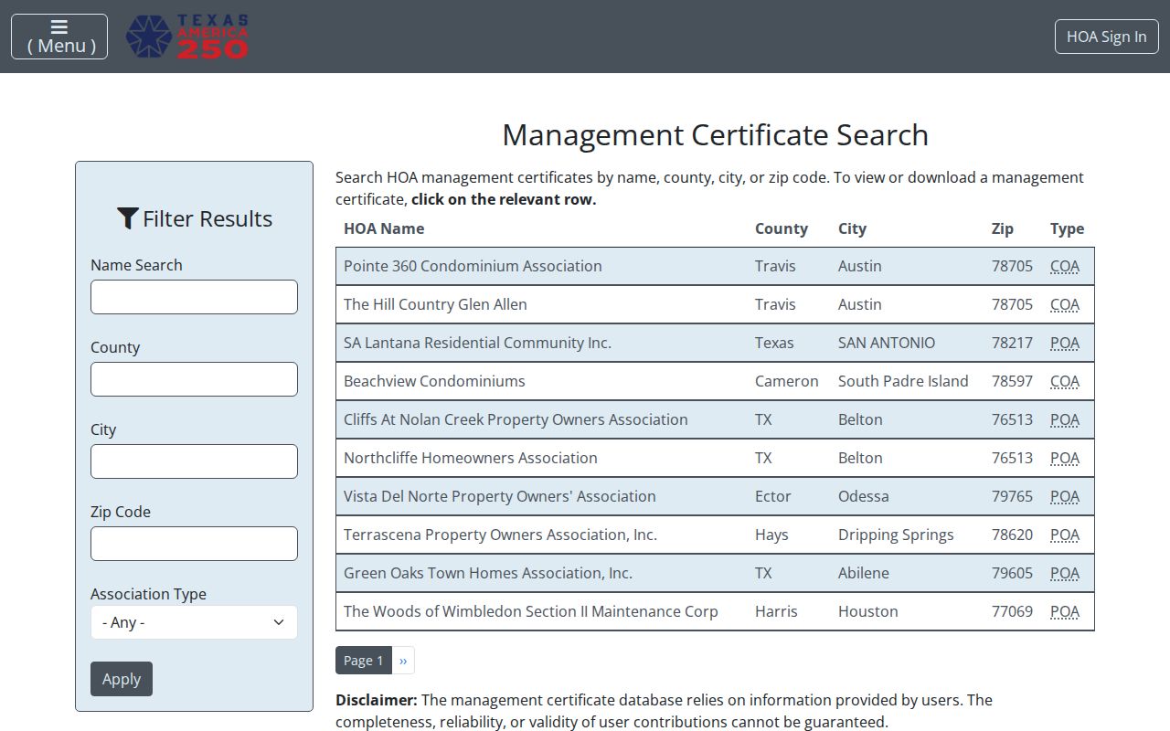
The screenshot shows the official certificate-search interface and its location filters. Use it to connect a parcel's subdivision context to an association name, then rely on the certificate itself for what it actually states.
Teal Run
Teal Run General Maintenance Association and Estates of Teal Run Homeowner Association appear in the Fresno/77545 certificate results.
Winfield and Creekmont
Winfield Lakes Homeowner Association and Creekmont Community Association appear in the inspected official results.
Other recorded names
Post Oak Pointe Homeowner's Association, Felro Trail Homeowners Association, and Cambridge Falls also appear in the official search results.
Teal Run Residents is a resident-run, non-HOA alliance with a block-captain and street-network context. It is useful for understanding local organization, but it is not government data and must not be presented as a public membership roll.
Fresno Old and New Blocks
County planning material uses Old Fresno and New Fresno to describe two record environments. New Fresno includes subdivision areas such as Teal Run and Andover Farms, where a block search may benefit from lot, block, section, and plat terms. Old Fresno refers to older linear development, vacant tracts, and limited commercial or industrial activity, where a road, survey, abstract, or historic legal description may be the better starting point.
For a dated block snapshot, George Memorial Library has Fort Bend newspapers, obituaries, census indexes, local histories, vertical files, and city or telephone directories. The inspected catalogs do not establish a complete Fresno reverse-directory run. A telephone subscriber or obituary is a historical lead, not proof that the person lived at a parcel on a given date. Pair it with the deed chain, plat, or other corroborating record.
Fresno Community Meeting Records Map
The Fort Bend County Fresno Community Meeting notice for April 16, 2026 brought together the Sheriff's Office, ESD 7, EMS, Engineering, Drainage, Parks and Recreation, and H-GAC. Its focus on mobility, drainage, public safety, and community development illustrates why a Fresno block question can lead to several county agencies rather than one municipal records counter.
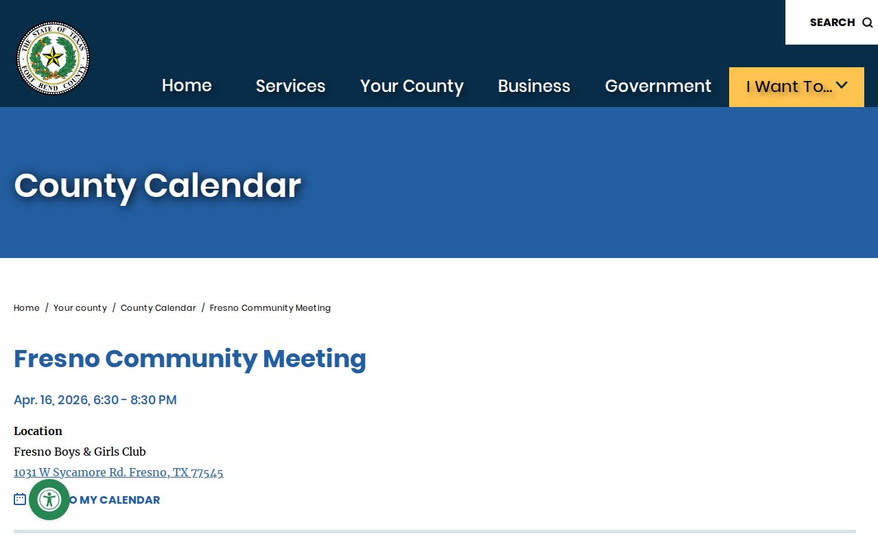
The meeting notice is a dated community-geography source, not a resident list. It helps identify agency routes for a road, drainage, park, or engineering question that appears while examining a Fresno block.
Note: The meeting notice gives agency context for Fresno, but each agency still controls its own records and update schedule.
Fresno Block Tools Compared
Official records and commercial neighbor-finder products answer different questions. A map, appraisal account, deed index, or association certificate has a named custodian and a defined record purpose. Commercial data-aggregation services can vary in freshness, sourcing, and opt-out practice. Neither category turns an owner name, historic address, or map marker into proof of current occupancy.
| Source type | Strength for a Fresno block | Limit to keep in mind |
|---|---|---|
| Official parcel and deed records | Links a legal parcel, appraisal account, or recorded instrument to its custodian | Shows dated property information, not a complete account of current occupants |
| Official association certificates | Names an association and its recorded certificate context | Does not establish membership or reveal every household |
| Commercial neighbor tools | May offer broad leads that require independent verification | Freshness, sourcing, and opt-out treatment can vary |
When a result matters, return to the public custodian and record the document date. County Clerk online images are marked unofficial, and a plain or certified copy may be needed where the underlying document controls.
Fresno Neighbor Lookup Privacy
Public records do not expose every detail about Fresno neighbors. Texas protections can cover phone numbers, Social Security numbers, driver-license or personal-ID numbers, birth dates, protected addresses, victim information, and ballot choices. The Texas Address Confidentiality Program provides a substitute address and mail forwarding for eligible participants. An FBCAD web opt-out can remove an owner name and mailing address from that public website, even though underlying records remain governed by law.
Use the minimum information necessary. A record being viewable is not permission to republish protected details or to make repeated unwanted contact. If information suggests immediate danger, contact 911 or the Fort Bend Sheriff instead of extending a directory search.